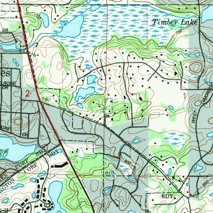
Map of Barrington, Illinois by USGS, 1993 – Lake Zurich, Fox River & Cuba Marsh Forest Preserve
Map of Barrington, Illinois by USGS, 1993 – Lake Zurich, Fox River & Cuba Marsh Forest Preserve
✅ Made In USA
✅ Quick Delivery
✅ Cruelty Free
BUNDLE & SAVE
BUNDLE & SAVE
Couldn't load pickup availability
-
Ordered
- - -
Order Ready
- - -
Delivered

Map of Barrington, Illinois by USGS, 1993 – Lake Zurich, Fox River & Cuba Marsh Forest Preserve
Published in 1993 by the United States Geological Survey, “Barrington Quadrangle” presents a finely detailed 1:24,000 topographic portrait of Barrington, Illinois, and its surrounding suburban and rural landscape at the close of the twentieth century. The map captures a moment when the northwest fringe of metropolitan Chicago was balancing long-established village life, commuter rail connectivity, affluent residential growth, and remaining open land. Barrington appears not merely as a town center, but as the anchor of a broader terrain of lakes, marshes, roads, townships, rail corridors, and preserves. Its USGS quadrangle format gives the landscape a measured authority, translating everyday places into a precise geographic record of elevation, hydrology, settlement, and land use.
The United States Geological Survey brought to this map more than a century of federal cartographic discipline. Founded to study and document the nation’s land, water, minerals, and natural hazards, the USGS became synonymous with the topographic quadrangle: practical, exacting, and quietly elegant. Here, its familiar visual language is especially effective. Contour lines articulate the subtle relief of northeastern Illinois, while symbols distinguish wooded tracts, developed areas, wetlands, roads, schools, railways, and water bodies. The result is a map of considerable clarity, designed for planning, field navigation, and environmental understanding, yet rich enough to reward close visual study.
Barrington itself occupies a historically interesting position within the Chicago region. Long associated with commuter life, equestrian estates, and prosperous suburban development, the village and its neighboring communities were shaped by transportation links as much as by topography. Roads such as Route 59 and Route 14 structure the map’s human geography, tracing the routes by which residents moved between village centers, rural edges, and the wider metropolitan network. Former and active rail lines add another layer, recalling the importance of rail access in Barrington’s development as a desirable community beyond Chicago’s urban core. By 1993, the area was already suburban, yet still visibly interwoven with farmland, open space, and water.
The surrounding names give the quadrangle much of its character: Lake Barrington, Tower Lakes, Port Barrington, Barrington Hills, Cuba Township, Ela Township, Cook County, and Lake County. Water is a defining presence, from Flint Creek and the Fox River to Brushwood Lake, Lake Atwood, Lake Zurich, and numerous smaller ponds and marshes. These features are not decorative; they explain settlement patterns, road alignments, preserved lands, and the environmental texture of the region. The map’s careful marking of wooded, agricultural, and developed land makes it particularly evocative of a transitional landscape, where subdivisions, estates, schools, lakeside communities, and remnants of rural Illinois coexist within a few miles.
As a historical document, “Barrington Quadrangle” preserves the land-use patterns of 1993 with uncommon precision. Since then, the area has seen continued residential expansion, infrastructure change, and evolving conservation priorities, making the map a valuable snapshot of a landscape in motion. Places such as Cuba Marsh Forest Preserve and Riverwalk Park point to the growing importance of protected natural areas amid suburban growth, while schools, roads, and neighborhood patterns reveal the civic framework of the time. Its contours and symbols invite comparison between past and present, offering a sophisticated record of how Barrington and its environs stood at a particular moment in the modern history of Chicagoland.
Cities, towns and places on this map
- Barrington, Illinois
- Lake Barrington
- Tower Lakes
- Port Barrington
- Cuba Township
- Cook County
- Lake County
- Flint Creek
- Fox River
- Brushwood Lake
- Lake Atwood
- Lake Zurich
- Stearns School
- Ela Township
- Barrington Hills
- Cuba Marsh Forest Preserve
- Riverwalk Park
- Intersecting roads, including Route 59 and Route 14
- Railways, including former railroad lines marked on the map
- Various lakes and ponds in the area
- Parks and preserved natural areas
Historical context & cartographic details
- Published by the United States Geological Survey (USGS), a U.S. government scientific agency.
- Historical 1:24,000 topographic map of Barrington, Illinois, and the surrounding area.
- Made in 1993 and carrying a 1993 imprint.
- Reflects topographic features, land use, and urban development patterns of the early 1990s.
- Shows Barrington’s setting as a commuter town within an affluent suburban environment.
- Uses detailed topographic styling, including elevation contours, water bodies, and vegetation types.
- Relief is represented through contour lines.
- Marks areas such as wooded, agricultural, and developed land.
- Useful for understanding recreational, planning, and environmental features of the area.
- Provides a snapshot of a landscape that has likely changed through later development.
Looking for a particular place? Review the detailed images to confirm that the town, landmark or feature you have in mind appears on the map. If you are unsure, ask our workshop to check before you order.
Detailed maps are especially rewarding at larger sizes, where names, boundaries and decorative features have more room to be appreciated. Use the close-up preview and size guide to choose the right scale for your wall.
This map looks amazing at sizes all the way up to 50in (125cm). If you are looking for a larger map, please get in touch.
The model in the listing images is holding the 16x20in (40x50cm) version of this map.
Where personalisation is available, you can add a short title or dedication, mark one meaningful place, or request one considered visual detail. See personalised map examples.
Every piece is printed to museum-grade archival standards using fade-resistant pigment inks on acid-free matte paper. Choose an unframed map print, framed map or canvas using the finish options above. Framed maps use crystal-clear optical acrylic and arrive ready to hang.
With its rich detail and strong sense of place, this map makes a considered gift for a new home, anniversary, retirement or anyone with a personal connection to the area shown. Still deciding? Explore our collection of rare old and vintage maps to discover another place, period or style.
Collapsible row
Collapsible row